The Polestar 2 puts Google Maps where it’s meant to be

Earlier this month I took the recently released Polestar 2 electric vehicle across the Golden Gate Bridge while I tried out the car for a few days. My time in the spacious sedan was smooth and quiet, thanks to the two electric motors and battery. In the front seat of the $59,900 EV, which has 291 miles of battery range, the infotainment system had an intuitive touchscreen layout that made it easy to use all the Google apps that come baked into the car.
But the best part? Where the Google Maps screen was located.
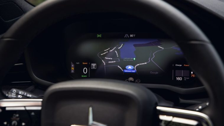
Instead of looking over to my right to catch a glimpse of the map and which lane I should get in, I looked straight ahead and a screen behind the wheel still showed detailed driving directions from Google Maps.
An electric ride on the Golden Gate Bridge.

Image: Polestar / Beadyeye
In the Polestar 2, the first all-electric sedan from Volvo’s luxury brand that arrived at the end of 2020, Google comes preloaded into the car. Instead of a music app, it’s YouTube Music. Podcasts? Google Podcasts. For voice control there’s Google Assistant. But most importantly there’s no generic navigation application or Apple CarPlay to display a map: The Polestar 2 comes with Google Maps.
The Polestar 2 is the first car to be fully powered by Google (the Volvo XC40 Recharge came out a few months later and also uses a Google interface). It displays the Google Maps graphics behind the steering wheel, alongside your speed and battery level. It’s a somewhat watered-down version of what’s displayed on the main center 11.15-inch touchscreen, but it’s still a detailed, color map that takes over the screen.
Google Maps behind the wheel.

Image: sasha lekach / mashable
Google Maps on the center console.

Image: polestar
The full map view display isn’t forced onto drivers. You can select from different driver display options, for example only getting high-level directions with arrows when it’s time to turn or merge. Or purists can keep all directions and mapping on the center screen.
But for me, the detailed map and highlighted route along with lane and turn instructions on the top of the 12.3-inch digital driver display was anything but distracting. It felt like finally the driver is shown to information that’s most important for the driver. Front and center. No head swiveling, no missing a turn while scanning the screen beside you.
On the center console you still have more interactivity and information from Google Maps, like the closing time of the restaurant you’re heading to, or if there’s an alternate route to shave off three minutes. And because the Polestar 2 is an electric car with a 78-kWh lithium-ion battery, Google Maps also shows charging stations and available plugs. Google recently added EV trip planning for the Polestar 2 and Volvo XC40 Recharge, the only two cars so far with Google Maps natively built in.
When Google Maps finally made it onto Apple CarPlay in 2018 I was elated, along with diehard Google Maps users. But the Polestar’s Google Maps display is next-level integration.
Published at Thu, 25 Feb 2021 14:00:00 +0000

Comments
Loading…